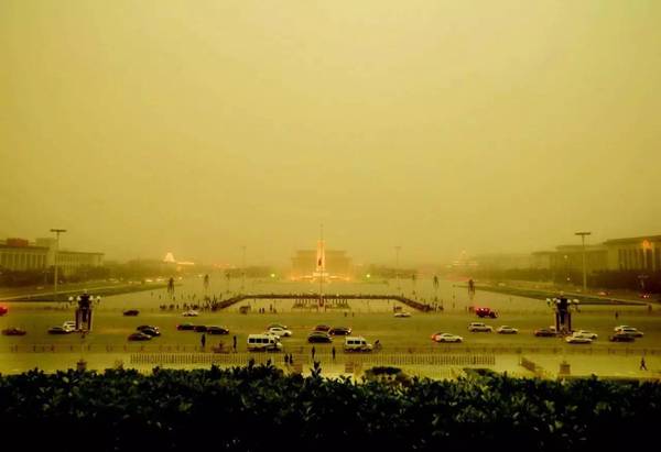
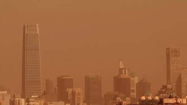
According to the prediction of the Beijing Municipal Environmental Protection Monitoring Center, a relatively large range of dust has begun to affect Beijing since yesterday, and dust may affect the Beijing area this morning.
This is already the second wave of dusty weather this year. However, you do not need to be nervous. The official Beijing Weibo also reminds you that this sandstorm is not a dust storm but a local sandstorm!

According to the Municipal Environmental Protection Monitoring Center, a relatively large range of dust has formed the day before yesterday in the Alashan Desert in western Inner Mongolia and in western Gansu. Currently in Ningxia and northern Shaanxi, from the monitoring data of air quality, the highest concentration of PM10 in dust-affected areas gradually decreased from 865 micrograms/cubic meter yesterday morning. At 11 hours, monitoring data showed that the highest concentration of PM10 was 322 micrograms/cubic. M, is expected to affect Beijing this morning.
From the forecast point of view, today's city's proliferation conditions have improved during the day, but may continue to be affected by sand and dust. It is expected that PM10 will become the primary pollutant and air quality will be mild to moderate.
At the same time, the northerly winds are noticeable during the day and gusts are expected to be around 7 levels. The local area may be accompanied by windfalls, and wind power is gradually weakened in the afternoon. According to the Ministry of Environmental Protection, three days from now, the country’s overall diffusion conditions are favorable. The air quality is mainly fine, and mild pollution may occur in some areas.
Due to possible sandstorms in the northwest and north China, some urban air quality may be one to two worse on the basis of the original forecast, and short-term moderate to severe pollution may occur.

Dust, sand, dust storms should be clearly distinguished!
Floating dust, sand blowing, and sandstorms, all three weather phenomena are visual obstacles.
Yansha: As the wind blows up dust from the ground, the air is quite turbid, and the horizontal visibility is greater than or equal to 1.0km to less than 10.0km.
Dust : Dust and fine sand float evenly in the sky, making horizontal visibility less than 10.0km. Most of the dust is dust from the distant upper reaches of the spread, or sandstorms, sand after the emergence of fine particles have not sunk floating air.
Sandstorm: As strong winds blow up large amounts of dust on the ground, the air is quite turbid and the horizontal visibility is less than 1.0km. According to the visibility, dust storms are divided into three levels: sandstorms (visibility 0.5km~less than 1.0km); strong sandstorms (visibility 0.05km~less than 0.5km); exceptionally strong sandstorms (visibility less than 0.05km)
Dust occurs when there is no wind or wind before and after the cold air passes through, and dust from distant places is transmitted through the high air flow. Or floating in the air due to dust that has not yet sank after the sandstorm or sandstorm weather. The visibility distance is less than 10km, and vertical visibility is also poor.
Yansha is due to the local or nearby dust being blown up and the visibility is significantly reduced. The visible distance is generally 1-10km. The sky is cloudy and the wind is big. In the spring and summer in the north, cold air appears when the mirror or air is unstable.
The cause of the sandstorm is similar to that of the Yansha, but the visibility is <1km. The wind is big. Often accompanied by strong convection or thunderstorm transit.
The difference between floating dust and blowing sand lies in that local sand is formed by blowing sand in and around the area. The floating dust often comes from afar (or it may be that dust is still floating in the air after Yansha passes); more importantly, when sand blows Larger winds have unstable air, while floating dusts have little or no wind. The main difference between sandstorms and sandstorms is the lower visibility.

The dusty weather in Beijing is mainly divided into two types. One is foreign dust, that is, it comes from Beijing's upper hand to some sand sources such as Mongolia and Inner Mongolia. After the dusty weather occurred in the local area, the dust that it raised was transmitted and settled downstream, affecting Beijing. The second type is Local Sands. If there is more than four levels of wind in Beijing, the surface of the ground will be easily lifted if the surface is dry.
However, according to experts, the most important dust weather in Beijing is foreign dust. Between 70% and 80% of dust weather in the year occurs in the spring, which is mainly related to the characteristics of the season.
In addition, dust weather is also an important factor influencing Beijing's spring air quality. However, from the monitoring data from 2006 to 2015, the air quality in Beijing has shown a clear declining trend due to the influence of sand and dust, and the dust weather has decreased. Halfway.
Plasma Cutting Machine not only can cut flat sheet , still also can cut on pipe .
plasma Cutting Machine & drilling machine , can regarding hole diameter to choose cutting or drilling .
1. Pipe cutting :Square pipe &round pipe all can cut . pipe diameter and length can customized regarding customers ' demands.
2.Metal sheet cutting :different thickness need different power source , China HUAYUAN & USA Hypertherm is two popular model power source
3. Drilling :if the hole diameter is too small , drilling function is better choose instead of plasma cutting .2mm-18mm is standard drilling diameter
OEM of Cnc Plasma Cutting Machine are Available
Pipe & Sheet Cutting & Drilling Machine
Sheet Metal Fabrication,Metal Fabrication,Metal Cutter,Pipe Drilling Machine
Jinan Huaxia Machinery Equipment CO.,Ltd , https://www.cnformingmachine.com